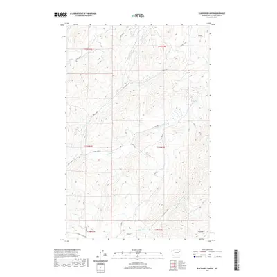
2020 Map of Blackhorse Canyon
USGS Topo · Published 2020About this map
Blackhorse Canyon serves as a primary geographic anchor in this section of Stevens County, where the topography is defined by the high elevations of Huckleberry Mtn and the various drainages that feed the local watershed. The landscape is a complex network of forest service roads and established thoroughfares like Cedonia-Addy Rd and Springdale Hunters Rd, which provide access to high-altitude clearings such as Schmid Meadows. The drainage patterns are particularly intricate, with N Fork Harvey Cr and S Fork Harvey Cr carving through the terrain alongside Smith Cr. This 2020 survey illustrates a region largely shaped by forestry and transit, with specific infrastructure like Cleveland Mine Rd hinting at the area's legacy of resource extraction. The map provides a contemporary record of how these remote mountain corridors are managed and accessed in the modern era.
Find a feature on this map
22 named features on this map. Tap any name to fly to it.
Don’t see what you’re looking for? This feature index may not catch every label — zoom into the map to look around manually.
Map Details
Editions of this 2020 Blackhorse Canyon Map
This is the sole edition of this map. No revisions or reprints were ever made.
Other maps of this area

1927 · Chewelah
USGS Topo · 1:125,000

1930 · Chewelah
USGS Topo · 1:125,000

1948 · Hunters
USGS Topo · 1:62,500

1950 · Hunters
USGS Topo · 1:62,500

1950 · Inchelium
USGS Topo · 1:62,500

1954 · Okanogan
USGS Topo · 1:250,000

1958 · Okanogan
USGS Topo · 1:250,000

1958 · Sandpoint
USGS Topo · 1:250,000

1963 · Sandpoint
USGS Topo · 1:250,000
1965 · Empey Mountain
USGS Topo · 1:24,000