
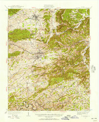
1932 Map of Blacksburg
USGS Topo · Published 1932About this map
The Virginia Polytechnic Institute grounds and the developing town of Blacksburg define the northern landscape of this early 1930s survey. As a major regional hub, Christiansburg sits central to a network of infrastructure including the Virginia Railway and Norfolk and Western Railway, which served the local extractive economy at Merrimac Mines and the Arsenic Mines to the southeast. The map reveals a dense rural social fabric, marked by numerous educational and religious centers such as the Christiansburg Industrial Sch and Mt Tabor Ch.
Find a feature on this map
80 named features on this map. Tap any name to fly to it.
Don’t see what you’re looking for? This feature index may not catch every label — zoom into the map to look around manually.
Map Details
Editions of this 1932 Blacksburg Map
2 editions found
Other maps of this area

1889 · Hillsville
USGS Topo · 1:125,000

1890 · Dublin
USGS Topo · 1:125,000

1890 · Christiansburg
USGS Topo · 1:125,000

1891 · Dublin
USGS Topo · 1:125,000

1892 · Hillsville
USGS Topo · 1:125,000

1896 · Hillsville
USGS Topo · 1:125,000

1923 · Pearisburg
USGS Topo · 1:62,500

1923 · Waiteville
USGS Topo · 1:62,500

1929 · Salem
USGS Topo · 1:48,000

1931 · Waiteville
USGS Topo · 1:48,000