
1931 Map of Waiteville
USGS Topo · Published 1931About this map
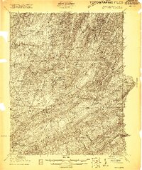
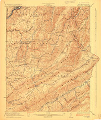
Potts Mountain and Sinking Creek Mountain dominate the western portion of this 1931 survey, which illustrates the dramatic ridge-and-valley topography along the border of Monroe County and Giles County. The settlement at Newport and the smaller outpost at Captain serve as focal points for the rural communities tucked into these high valleys. This advance sheet captures the region just before the mid-century, showing the placement of local landmarks like Clover Hollow Ch and Mt Olive Ch that anchored social life for family farms. Notable landmarks such as White Rocks and Lone Pine Peak provide a high-resolution look at the terrain that defined transportation routes through Rocky Gap. The drainage patterns of Big Stony Creek and Johns Creek further illustrate the difficult geography that local residents navigated daily.
Find a feature on this map
23 named features on this map. Tap any name to fly to it.
Don’t see what you’re looking for? This feature index may not catch every label — zoom into the map to look around manually.
Map Details
Editions of this 1931 Waiteville Map
This is the sole edition of this map. No revisions or reprints were ever made.
Other maps of this area

1887 · Hinton
USGS Topo · 1:125,000

1887 · Lewisburg
USGS Topo · 1:125,000

1890 · Dublin
USGS Topo · 1:125,000

1890 · Christiansburg
USGS Topo · 1:125,000

1891 · Lewisburg
USGS Topo · 1:125,000

1891 · Dublin
USGS Topo · 1:125,000

1892 · Hinton
USGS Topo · 1:125,000

1921 · Alderson
USGS Topo · 1:48,000
1921 · Ronceverte
USGS Topo · 1:48,000
1923 · Ronceverte
USGS Topo · 1:62,500