
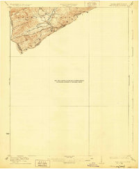
1923 Map of Waiteville
USGS Topo · Published 1923About this map
Waiteville sits as the central settlement on this 1921 survey, nestled in a valley where the Norfolk and Western Ry follows the course of Potts Cr. The landscape is dominated by the massive ridge of Peters Mountain to the north and Little Mtn to the south, marking the complex border between Monroe County, West Virginia, and Craig County, Virginia. The drainage pattern of the North Fork and South Fork reveals the narrow, linear agricultural and transport corridors of the early twentieth century. This sheet captures a specific moment in the regional geography before later development, showing the proximity of the rail line to landmarks like Arnold Knob and the various tributaries including Ray Branch and Crosier Branch that feed into the larger creek system.
Find a feature on this map
14 named features on this map. Tap any name to fly to it.
Don’t see what you’re looking for? This feature index may not catch every label — zoom into the map to look around manually.
Map Details
Editions of this 1923 Waiteville Map
2 editions found
Other maps of this area

1887 · Hinton
USGS Topo · 1:125,000

1887 · Lewisburg
USGS Topo · 1:125,000

1890 · Dublin
USGS Topo · 1:125,000

1890 · Christiansburg
USGS Topo · 1:125,000

1891 · Lewisburg
USGS Topo · 1:125,000

1891 · Dublin
USGS Topo · 1:125,000

1892 · Hinton
USGS Topo · 1:125,000

1921 · Alderson
USGS Topo · 1:48,000

1921 · Ronceverte
USGS Topo · 1:48,000

1923 · Ronceverte
USGS Topo · 1:62,500