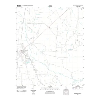
2011 Map of Blackshear East
USGS Topo · Published 2011About this map
The Alabaha River meanders through the landscape east of Blackshear, defining a terrain of wetland branches and rural settlements. This 2011 survey illustrates a community deeply rooted in its local geography, with numerous family and community burial grounds such as Strickland Cemetery, Smith Cemetery, and Browns Cemetery scattered across the countryside. The presence of the Lakeview Country Club and its associated Lakeview Country Club Lake near the town center indicates established recreation, while the Forestry-Strip Airport to the northeast points to the region's industrial connection to timber resources.
Find a feature on this map
78 named features on this map. Tap any name to fly to it.
Don’t see what you’re looking for? This feature index may not catch every label — zoom into the map to look around manually.
Map Details
Editions of this 2011 Blackshear East Map
This is the sole edition of this map. No revisions or reprints were ever made.
Other maps of this area

1953 · Waycross
USGS Topo · 1:250,000

1958 · Waycross
USGS Topo · 1:250,000
1966 · Hoboken East
USGS Topo · 1:24,000

1967 · Hoboken West
USGS Topo · 1:24,000

1967 · Waycross East
USGS Topo · 1:24,000

1971 · Blackshear East
USGS Topo · 1:24,000

1971 · Patterson
USGS Topo · 1:24,000
1971 · Screven
USGS Topo · 1:24,000

1971 · Blackshear West
USGS Topo · 1:24,000

1971 · Mershon
USGS Topo · 1:24,000