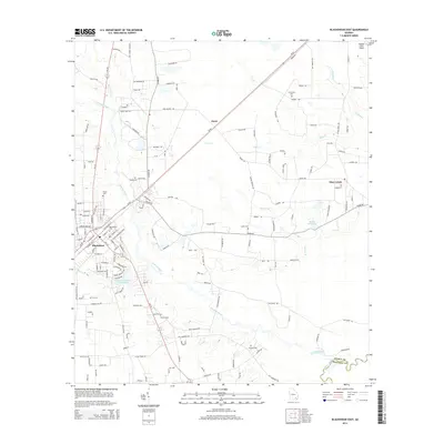
2014 Map of Blackshear East
USGS Topo · Published 2014About this map
The Alabaha River winds through the heart of this landscape, its floodplains and tributaries like Otter Cr and Brown Br defining the rural geography between the settlements of Blackshear and Owen. The eastern portion of the Blackshear area is characterized by a high density of family and community burial grounds, such as Blackshear Cem, Shiloh Cem, and Strickland Cem, providing critical reference points for genealogists and local historians.
Find a feature on this map
146 named features on this map. Tap any name to fly to it.
Don’t see what you’re looking for? This feature index may not catch every label — zoom into the map to look around manually.
Map Details
Editions of this 2014 Blackshear East Map
This is the sole edition of this map. No revisions or reprints were ever made.
Other maps of this area

1953 · Waycross
USGS Topo · 1:250,000

1958 · Waycross
USGS Topo · 1:250,000
1966 · Hoboken East
USGS Topo · 1:24,000

1967 · Hoboken West
USGS Topo · 1:24,000

1967 · Waycross East
USGS Topo · 1:24,000

1971 · Blackshear East
USGS Topo · 1:24,000

1971 · Patterson
USGS Topo · 1:24,000
1971 · Screven
USGS Topo · 1:24,000

1971 · Blackshear West
USGS Topo · 1:24,000

1971 · Mershon
USGS Topo · 1:24,000