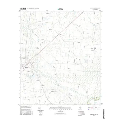
2017 Map of Blackshear East
USGS Topo · Published 2017About this map
Blackshear and its surrounding wetlands form the heart of this landscape, situated at a junction where the town meets the serpentine course of the Alabaha River. The geography is defined by an extensive network of swamps and branches, including Mud Swamp and Cross Swamp, which dominate the eastern and southern reaches of the quadrangle. For genealogists and local historians, the area is rich with family-named burial sites such as Strickland Cem, Smith Cem, and Browns Cem, scattered across the rural countryside near smaller settlements like Owen. The map shows a clear transition from the more developed grid of Blackshear to the winding country roads and hydraulic features like Walker Mill Pond. The southernmost border captures a bend in the Satilla River, where the Pierce Co and Brantley Co line follows the natural waterway through the dense Raulerson Swamp.
Find a feature on this map
123 named features on this map. Tap any name to fly to it.
Don’t see what you’re looking for? This feature index may not catch every label — zoom into the map to look around manually.
Map Details
Editions of this 2017 Blackshear East Map
This is the sole edition of this map. No revisions or reprints were ever made.
Other maps of this area

1953 · Waycross
USGS Topo · 1:250,000

1958 · Waycross
USGS Topo · 1:250,000
1966 · Hoboken East
USGS Topo · 1:24,000

1967 · Hoboken West
USGS Topo · 1:24,000

1967 · Waycross East
USGS Topo · 1:24,000

1971 · Blackshear East
USGS Topo · 1:24,000

1971 · Patterson
USGS Topo · 1:24,000
1971 · Screven
USGS Topo · 1:24,000

1971 · Blackshear West
USGS Topo · 1:24,000

1971 · Mershon
USGS Topo · 1:24,000