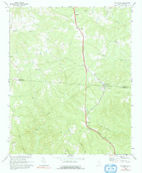
1968 Map of Blackstock
USGS Topo · Published 1991About this map
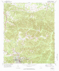
The Southern railroad corridor dictates the settlement pattern across this South Carolina piedmont landscape, where the small communities of Blackstock, Woodward, Cornwell, and McKeown are spaced as rhythmic stops along the line. Straddling the boundary between Chester Co and Fairfield Co, the area is defined by a series of south-flowing drainage systems, including Big Wateree Creek and the Little River, which carve through the terrain. The social fabric of the late 1960s is clearly visible through a dense network of country churches, such as Antioch Ch, Armenia Ch, and New Hope Ch, many of which feature adjacent cemeteries. While the major villages cling to the rail and highway, the western and southern reaches of the map show more dispersed rural holdings and a primitive road network, including a Jeep Trail near the Little River.
Find a feature on this map
28 named features on this map. Tap any name to fly to it.
Don’t see what you’re looking for? This feature index may not catch every label — zoom into the map to look around manually.
Map Details
Editions of this 1968 Blackstock Map
2 editions found
Other maps of this area

1904 · Columbia
USGS Topo · 1:125,000

1941 · Spartanburg
USGS Topo · 1:250,000

1953 · Spartanburg
USGS Topo · 1:250,000

1960 · Spartanburg
USGS Topo · 1:250,000

1963 · Spartanburg
USGS Topo · 1:250,000

1964 · Spartanburg
USGS Topo · 1:250,000
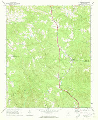
1968 · Blackstock
USGS Topo · 1:24,000
1969 · Lebanon
USGS Topo · 1:24,000
1969 · Salem Crossroads
USGS Topo · 1:24,000
1969 · Winnsboro
USGS Topo · 1:24,000