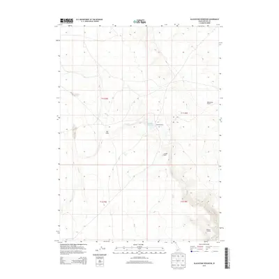
2013 Map of Blackstone Reservoir
USGS Topo · Published 2013About this map
Blackstone Ranch serves as a lone marker of habitation in this arid expanse of Owyhee County, situated near the seasonal waters of Blackstone Reservoir. The landscape is defined by its drainage patterns and distinct topographic depressions, most notably the Big Holes and the carved terrain of Juniper Draw. To the east, the elevation shifts into the arid Blackstone Desert, while the southern reaches of the quadrangle transition into the high-elevation terrain of Bighorn Country. This 2013 survey illustrates the remote character of southwestern Idaho, where water sources like Louise Cr, Nit Cr, and Sheep Cr dictate the layout of the few established ranching outposts and primitive roads. The map provides a clear view of the Public Land Survey System grid, including the boundaries of t11s r5e and t11s r6e, which organize this vast territory.
Find a feature on this map
13 named features on this map. Tap any name to fly to it.
Don’t see what you’re looking for? This feature index may not catch every label — zoom into the map to look around manually.
Map Details
Editions of this 2013 Blackstone Reservoir Map
This is the sole edition of this map. No revisions or reprints were ever made.
Other maps of this area

1955 · Twin Falls
USGS Topo · 1:250,000

1956 · Big Hill
USGS Topo · 1:62,500

1956 · Winter Camp
USGS Topo · 1:62,500

1958 · Twin Falls
USGS Topo · 1:250,000

1979 · Indian Hot Springs
USGS Topo · 1:24,000

1979 · Blackstone Reservoir
USGS Topo · 1:24,000
1979 · Grasmere Reservoir
USGS Topo · 1:24,000

1979 · Cave Draw
USGS Topo · 1:24,000
1979 · Buster Butte
USGS Topo · 1:24,000
1979 · Grasmere
USGS Topo · 1:24,000