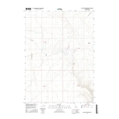
2017 Map of Blackstone Reservoir
USGS Topo · Published 2017About this map
Blackstone Reservoir sits at the heart of this high-desert landscape in southwestern Idaho, serving as a critical water source in a region defined by its arid plateaus. The surrounding terrain is marked by seasonal drainages such as Louise Cr and Sheep Cr, which carve through the open range. The area is largely defined by public land divisions, as seen in the grid of townships T11S and T12S, reflecting the administrative heritage of the Owyhee backcountry. Notable geographic depressions like Big Holes and the winding Juniper Draw punctuate the topography near the reservoir. The presence of the Blackstone Grasmere Rd indicates the primary transit corridor through the Blackstone Desert, connecting this isolated rangeland to the broader region. This 2017 survey captures the intersection of cattle-ranching geography and modern hydrological management in a sparsely populated section of the state.
Find a feature on this map
12 named features on this map. Tap any name to fly to it.
Don’t see what you’re looking for? This feature index may not catch every label — zoom into the map to look around manually.
Map Details
Editions of this 2017 Blackstone Reservoir Map
This is the sole edition of this map. No revisions or reprints were ever made.
Other maps of this area

1955 · Twin Falls
USGS Topo · 1:250,000

1956 · Big Hill
USGS Topo · 1:62,500

1956 · Winter Camp
USGS Topo · 1:62,500

1958 · Twin Falls
USGS Topo · 1:250,000

1979 · Indian Hot Springs
USGS Topo · 1:24,000

1979 · Blackstone Reservoir
USGS Topo · 1:24,000
1979 · Grasmere Reservoir
USGS Topo · 1:24,000

1979 · Cave Draw
USGS Topo · 1:24,000
1979 · Buster Butte
USGS Topo · 1:24,000
1979 · Grasmere
USGS Topo · 1:24,000