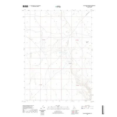
2020 Map of Blackstone Reservoir
USGS Topo · Published 2020About this map
Blackstone Reservoir sits at the center of this high-desert landscape in Owyhee County, serving as a vital water source in an arid region defined by seasonal drainages and vast open spaces. The map reveals a remote geography where human infrastructure is limited to the winding Blackstone Grasmere Rd, which provides the primary access through the Blackstone Desert. This area is characterized by its complex hydrology, with ephemeral watercourses such as Louse Cr, Nit Cr, and Sheep Cr cutting through the terrain. The presence of Juniper Draw suggests the localized vegetation patterns found within the draws and depressions of the basaltic plateau. This survey, compiled from data ranging from 2002 to 2020, captures the persistent character of this rangeland, where modern land management and traditional western geography intersect.
Find a feature on this map
11 named features on this map. Tap any name to fly to it.
Don’t see what you’re looking for? This feature index may not catch every label — zoom into the map to look around manually.
Map Details
Editions of this 2020 Blackstone Reservoir Map
This is the sole edition of this map. No revisions or reprints were ever made.
Other maps of this area

1955 · Twin Falls
USGS Topo · 1:250,000

1956 · Big Hill
USGS Topo · 1:62,500

1956 · Winter Camp
USGS Topo · 1:62,500

1958 · Twin Falls
USGS Topo · 1:250,000

1979 · Indian Hot Springs
USGS Topo · 1:24,000

1979 · Blackstone Reservoir
USGS Topo · 1:24,000
1979 · Grasmere Reservoir
USGS Topo · 1:24,000

1979 · Cave Draw
USGS Topo · 1:24,000
1979 · Buster Butte
USGS Topo · 1:24,000
1979 · Grasmere
USGS Topo · 1:24,000