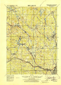
1919 Map of Blackstone
USGS Topo · Published 1921About this map
Industrial villages and mill towns dominate this landscape along the Blackstone River corridor, documented here by the Corps of Engineers, U. S. Army just after the First World War. The map traces the dense intersection of manufacturing and transport, where the Mumford River and West River powered early industry in settlements like Whitinsville, Fisherville, and Saundersville. Rail lines including the New York New Haven and Hartford R. R. and the Boston & Albany R. R. crisscross the valley, linking these production hubs to larger markets. Natural landmarks such as the geological formation at Purgatory Chasm contrast with the engineered landscape of the northern reservoirs and the developed riverbanks of Blackstone and Millville near the Rhode Island border.
Find a feature on this map
108 named features on this map. Tap any name to fly to it.
Don’t see what you’re looking for? This feature index may not catch every label — zoom into the map to look around manually.
Map Details
Editions of this 1919 Blackstone Map
2 editions found
Other maps of this area

1885 · Worcester
USGS Topo · 1:62,500

1886 · Worcester
USGS Topo · 1:62,500

1886 · Blackstone
USGS Topo · 1:62,500

1886 · Framingham
USGS Topo · 1:62,500

1887 · Franklin
USGS Topo · 1:62,500

1887 · Providence
USGS Topo · 1:62,500

1887 · Marlboro
USGS Topo · 1:62,500

1889 · Providence
USGS Topo · 1:62,500

1889 · Marlboro
USGS Topo · 1:62,500

1889 · Blackstone
USGS Topo · 1:62,500