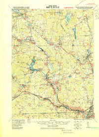
1919 Map of Blackstone
USGS Topo · Published 1919About this map
The Blackstone River valley serves as the industrial and transit spine of this 1919 military survey, documenting a landscape where rail lines and river power shaped the growth of numerous mill towns. Several corridors including the Boston and Albany RR and the Providence and Worcester RR converge here, connecting settlements like Whitinsville, Uxbridge, and Millville. The terrain is defined by a series of prominent elevations such as Brigham Hill and Miscoe Hill, punctuated by the distinctive geological formation at Purgatory Chasm. This sheet, corrected by the Corps of Engineers, U.S. Army just after the Great War, captures the region's complex water management system, from the Mumford River to the reservoirs around Hopkinton and Woodville. It provides a clear record of early 20th-century Massachusetts and Rhode Island borderlands before modern highway expansion altered the valley.
Find a feature on this map
88 named features on this map. Tap any name to fly to it.
Don’t see what you’re looking for? This feature index may not catch every label — zoom into the map to look around manually.
Map Details
Editions of this 1919 Blackstone Map
2 editions found
Other maps of this area

1885 · Worcester
USGS Topo · 1:62,500

1886 · Worcester
USGS Topo · 1:62,500

1886 · Blackstone
USGS Topo · 1:62,500

1886 · Framingham
USGS Topo · 1:62,500

1887 · Franklin
USGS Topo · 1:62,500

1887 · Providence
USGS Topo · 1:62,500

1887 · Marlboro
USGS Topo · 1:62,500

1889 · Providence
USGS Topo · 1:62,500

1889 · Marlboro
USGS Topo · 1:62,500

1889 · Blackstone
USGS Topo · 1:62,500