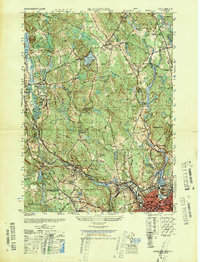
1948 Map of Blackstone
USGS Topo · Published 1948About this map
The Blackstone River valley in the late 1940s is defined by a dense network of industrial settlements and rural hilltop communities spanning the Massachusetts and Rhode Island border. Heavy rail traffic from the New York New Haven and Hartford railroad connects the bustling manufacturing centers of Woonsocket and Blackstone to the surrounding hills. This survey records a landscape in transition, where early aviation landmarks like the Mendon Landing Field and an Airway Beacon sit near 18th-century heritage sites like the Chestnut Hill Meeting House. From the textile villages of Wheelockville and Waterford to the numerous cemeteries such as Precious Blood Cem and St Michael Ukrainian Cem, the map documents the diverse immigrant and labor history of the region. Notable water features like Nipmuck Pond and Ironstone Reservoir highlight the area's long-standing reliance on river-powered industry.
Find a feature on this map
74 named features on this map. Tap any name to fly to it.
Don’t see what you’re looking for? This feature index may not catch every label — zoom into the map to look around manually.
Map Details
Editions of this 1948 Blackstone Map
This is the sole edition of this map. No revisions or reprints were ever made.
Other maps of this area

1886 · Blackstone
USGS Topo · 1:62,500

1887 · Franklin
USGS Topo · 1:62,500

1887 · Providence
USGS Topo · 1:62,500

1889 · Providence
USGS Topo · 1:62,500

1889 · Blackstone
USGS Topo · 1:62,500

1889 · Franklin
USGS Topo · 1:62,500

1889 · Burrillville
USGS Topo · 1:62,500

1893 · Franklin
USGS Topo · 1:62,500

1893 · Blackstone
USGS Topo · 1:62,500

1894 · Burrillville
USGS Topo · 1:62,500