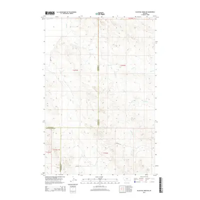
2014 Map of Blacktail Creek SW
USGS Topo · Published 2014About this map
The Powder River drainage defines this high-plains landscape where three Montana counties converge. This 2014 survey captures a sparsely populated region where administrative boundaries between Custer, Powder River, and Carter counties intersect. The map documents a terrain shaped by seasonal watercourses, including Spring Creek, Whitetail Creek, and Dry Creek, which cut through the drainage basins feeding the main river valley. Low-impact infrastructure is evident through a limited network of gravel and unimproved routes such as Powderville Road and Brewer Road. These corridors, along with the BLM Road, provide the primary access for land management and ranching operations in a landscape largely defined by the Public Land Survey System grids of Township 1 North and 1 South.
Find a feature on this map
17 named features on this map. Tap any name to fly to it.
Don’t see what you’re looking for? This feature index may not catch every label — zoom into the map to look around manually.
Map Details
Editions of this 2014 Blacktail Creek SW Map
This is the sole edition of this map. No revisions or reprints were ever made.
Other maps of this area

1954 · Ekalaka
USGS Topo · 1:250,000

1956 · Ekalaka
USGS Topo · 1:250,000

1958 · Ekalaka
USGS Topo · 1:250,000

1965 · Ekalaka
USGS Topo · 1:250,000

1979 · Blacktail Creek NW
USGS Topo · 1:24,000

1979 · Blacktail Creek SE
USGS Topo · 1:24,000
1979 · Mills Creek East
USGS Topo · 1:24,000

1979 · Board Corral Creek
USGS Topo · 1:24,000

1979 · Blacktail Creek SW
USGS Topo · 1:24,000

1979 · Powderville
USGS Topo · 1:24,000