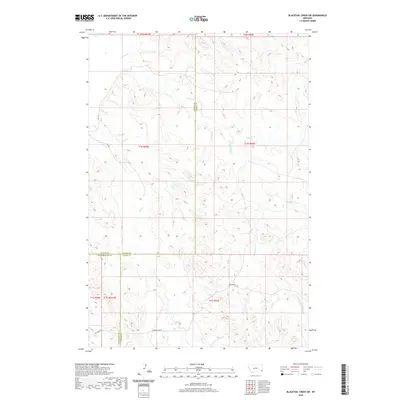
2020 Map of Blacktail Creek SW
USGS Topo · Published 2020About this map
The high plains of southeastern Montana are defined by a network of seasonal drainages and early cattle trails in this 2020 landscape. This area, where Powderville Rd and Exalaka Rd intersect near the corners of Powder River, Custer, and Carter Counties, retains a remote character established during the open-range era. The map details the complex branching of Whitetail Creek and Spring Creek, showing how these watercourses dictate the local topography and the placement of rural routes like Rd 429 and Rd 464. Local researchers can trace the precise boundaries of several townships including t1n r55e and t1s r55e, which organize the vast, sparsely settled ranching territory. The absence of concentrated settlements highlights a landscape where movement is still guided by the ancient paths of the creeks.
Find a feature on this map
18 named features on this map. Tap any name to fly to it.
Don’t see what you’re looking for? This feature index may not catch every label — zoom into the map to look around manually.
Map Details
Editions of this 2020 Blacktail Creek SW Map
This is the sole edition of this map. No revisions or reprints were ever made.
Other maps of this area

1954 · Ekalaka
USGS Topo · 1:250,000

1956 · Ekalaka
USGS Topo · 1:250,000

1958 · Ekalaka
USGS Topo · 1:250,000

1965 · Ekalaka
USGS Topo · 1:250,000

1979 · Blacktail Creek NW
USGS Topo · 1:24,000

1979 · Blacktail Creek SE
USGS Topo · 1:24,000
1979 · Mills Creek East
USGS Topo · 1:24,000

1979 · Board Corral Creek
USGS Topo · 1:24,000

1979 · Blacktail Creek SW
USGS Topo · 1:24,000

1979 · Powderville
USGS Topo · 1:24,000