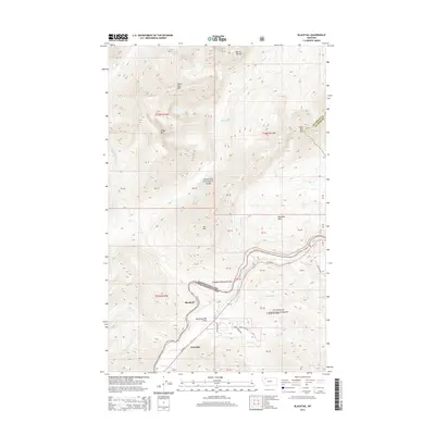
2014 Map of Blacktail
USGS Topo · Published 2014About this map
Theodore Roosevelt Pass serves as a critical corridor through the high peaks of the Continental Divide, marking the boundary between Glacier National Park and the Flathead National Forest. This 2014 survey documents the transportation artery of US Hwy 2 as it winds alongside Bear Cr, connecting the small mountain settlements of Blacktail and Snowslip. The topography is defined by significant summits including Brave Dog Mtn, Little Dog Mtn, and Sheep Mtn, while the southern reaches of the map transition into the McCartysville Flats. The proximity of water sources like Ole Lake and Giefer Cr to the historic pass highlights the enduring importance of this passage for both natural drainage and human transit across the northern Rocky Mountains.
Find a feature on this map
48 named features on this map. Tap any name to fly to it.
Don’t see what you’re looking for? This feature index may not catch every label — zoom into the map to look around manually.
Map Details
Editions of this 2014 Blacktail Map
This is the sole edition of this map. No revisions or reprints were ever made.
Other maps of this area

1913 · Marias Pass
USGS Topo · 1:125,000

1914 · Nyack
USGS Topo · 1:125,000

1958 · Red Plume Mountain
USGS Topo · 1:24,000

1958 · Nimrod
USGS Topo · 1:24,000

1958 · Mount Bradley
USGS Topo · 1:24,000

1960 · Cut Bank
USGS Topo · 1:250,000

1963 · Cut Bank
USGS Topo · 1:250,000

1964 · Cut Bank
USGS Topo · 1:250,000

1964 · Essex
USGS Topo · 1:24,000
1964 · Mount Saint Nicholas
USGS Topo · 1:24,000