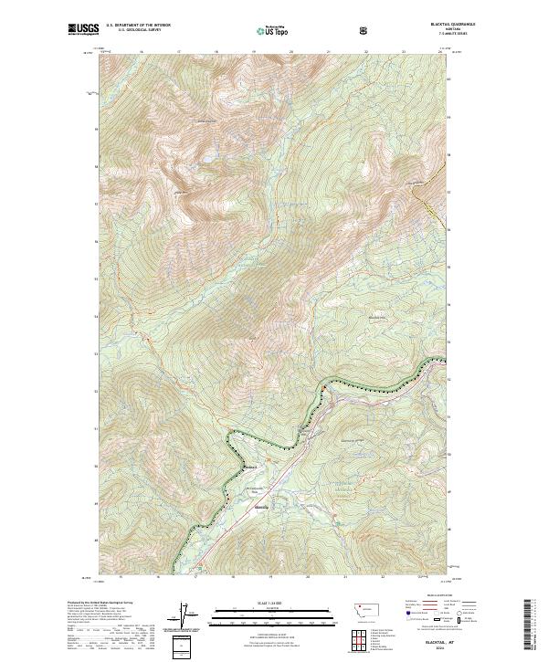
2024 Map of Blacktail
USGS Topo · Published 2024About this map
Blacktail and Snowslip sit within the high elevations of the Continental Divide, where the borders of Glacier National Park meet the Flathead National Forest and Great Bear Wilderness. The landscape is defined by the sharp peaks of the Sawtooth Range and the John F Stevens Canyon, a critical corridor for transcontinental transit through Theodore Roosevelt Pass. This terrain, dominated by massifs like Brave Dog Mtn and Sheep Mtn, is etched with an extensive network of footpaths including the Ole Creek Trl and Fielding Trl. The inclusion of McCartysville Flats points to the area's history as a site of early settlement and railway labor camps during the construction of the Great Northern Railway. The drainage patterns of Ole Creek, Bear Creek, and Mule Creek illustrate the complex hydrology of this mountainous region, where numerous trails provide access to the remote backcountry of the northern Rockies.
Find a feature on this map
40 named features on this map. Tap any name to fly to it.
Don’t see what you’re looking for? This feature index may not catch every label — zoom into the map to look around manually.
Map Details
Editions of this 2024 Blacktail Map
This is the sole edition of this map. No revisions or reprints were ever made.
Other maps of this area

1913 · Marias Pass
USGS Topo · 1:125,000

1914 · Nyack
USGS Topo · 1:125,000

1958 · Red Plume Mountain
USGS Topo · 1:24,000

1958 · Nimrod
USGS Topo · 1:24,000

1958 · Mount Bradley
USGS Topo · 1:24,000

1960 · Cut Bank
USGS Topo · 1:250,000

1963 · Cut Bank
USGS Topo · 1:250,000

1964 · Cut Bank
USGS Topo · 1:250,000

1964 · Essex
USGS Topo · 1:24,000
1964 · Mount Saint Nicholas
USGS Topo · 1:24,000