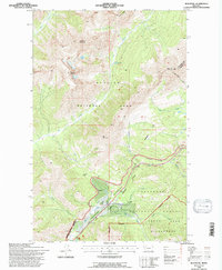
1994 Map of Blacktail
USGS Topo · Published 1997About this map
Glacier National Park and the Flathead National Forest dominate this mountain landscape, meeting at the Continental Divide in northwestern Montana. Transportation history is etched into the terrain along the corridor of Theodore Roosevelt Pass, where the Burlington Northern railroad follows the contours of Bear Creek and Ole Creek. The map records small railway-adjacent settlements and outpost markers such as Snowslip, Blacktail, and the Fielding Patrol Cabin.
Find a feature on this map
32 named features on this map. Tap any name to fly to it.
Don’t see what you’re looking for? This feature index may not catch every label — zoom into the map to look around manually.
Map Details
Editions of this 1994 Blacktail Map
This is the sole edition of this map. No revisions or reprints were ever made.
Other maps of this area

1913 · Marias Pass
USGS Topo · 1:125,000

1914 · Nyack
USGS Topo · 1:125,000

1958 · Red Plume Mountain
USGS Topo · 1:24,000

1958 · Nimrod
USGS Topo · 1:24,000

1958 · Mount Bradley
USGS Topo · 1:24,000

1960 · Cut Bank
USGS Topo · 1:250,000

1963 · Cut Bank
USGS Topo · 1:250,000

1964 · Cut Bank
USGS Topo · 1:250,000

1964 · Essex
USGS Topo · 1:24,000
1964 · Mount Saint Nicholas
USGS Topo · 1:24,000