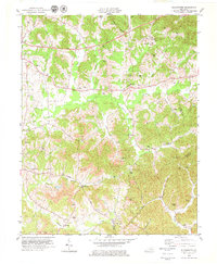
1979 Map of Blackwater
USGS Topo · Published 1979About this map
Wilderness Road winds through this rugged portion of the Kentucky mountains, tracing a historic passage through Laurel and Clay counties toward the Knox County line. The landscape is defined by the tight valley of the Laurel River and its numerous tributaries, including Blackwater Creek and Robinson Creek. Small rural communities like Marydell, Lida, and Robinson anchor the terrain, often centered around local congregations such as Robinson Creek Ch and Merrimac Ch. Extensive strip mines are visible throughout the central and southern sections of the quadrangle, reflecting the significant impact of the coal industry on the geography by the late 1970s. For the family historian, the map preserves the locations of numerous family-named burial grounds, including Gregory Cem, McFadden Cem, and Blanton Cem, which sit alongside historic school sites like Bush Sch.
Find a feature on this map
63 named features on this map. Tap any name to fly to it.
Don’t see what you’re looking for? This feature index may not catch every label — zoom into the map to look around manually.
Map Details
Editions of this 1979 Blackwater Map
This is the sole edition of this map. No revisions or reprints were ever made.
Other maps of this area

1886 · Cumberland Gap
USGS Topo · 1:125,000

1888 · Cumberland Gap
USGS Topo · 1:125,000

1890 · Williamsburg
USGS Topo · 1:125,000

1891 · Manchester
USGS Topo · 1:125,000

1891 · Cumberland Gap
USGS Topo · 1:125,000

1893 · London
USGS Topo · 1:125,000

1894 · Williamsburg
USGS Topo · 1:125,000

1897 · London
USGS Topo · 1:125,000

1952 · Portersburg
USGS Topo · 1:24,000

1952 · Corbin
USGS Topo · 1:24,000