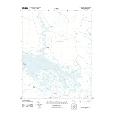
2011 Map of Blackwater River
USGS Topo · Published 2011About this map
The Little Blackwater River and Transquaking River dominate this low-lying coastal landscape, forming a complex network of marshes, ponds, and tidal guts. Small rural settlements like Bucktown, Seward, and Indianbone are connected by a few winding roads such as Maple Dam Rd and Bucktown Rd. The map illustrates the historical reliance on water access for transportation and commerce, evidenced by landings and wharves such as Barnes Landing and Shorters Wharf. Significant genealogical markers include Scotts Chapel Cemetery and Insley Cemetery, which anchor the small communities in this saturated environment. The terrain is characterized by a series of shallow bodies of water, including Harpers Pond, Goose Pond, and the uniquely named Hog Rotting Pond, illustrating the intricate drainage patterns of the Dorchester County wetlands.
Find a feature on this map
45 named features on this map. Tap any name to fly to it.
Don’t see what you’re looking for? This feature index may not catch every label — zoom into the map to look around manually.
Map Details
Editions of this 2011 Blackwater River Map
This is the sole edition of this map. No revisions or reprints were ever made.
Other maps of this area

1898 · Choptank
USGS Topo · 1:125,000

1898 · St. Marys
USGS Topo · 1:125,000

1903 · Nanticoke
USGS Topo · 1:62,500

1904 · Oxford
USGS Topo · 1:62,500

1905 · Crapo
USGS Topo · 1:62,500

1905 · Hurlock
USGS Topo · 1:62,500

1906 · St. Marys
USGS Topo · 1:125,000

1908 · Choptank
USGS Topo · 1:125,000

1942 · Church Creek
USGS Topo · 1:24,000
1942 · Honga
USGS Topo · 1:24,000