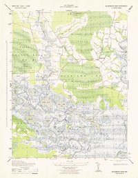
1943 Map of Blackwater River
USGS Topo · Published 1943About this map
The labyrinthine wetlands of Dorchester County define this 1943 survey, where the Blackwater River and Little Blackwater River wind through a landscape of tidal marshes and freshwater ponds. Much of the western territory is designated as the Blackwater National Wildlife Refuge, established just a decade prior to this mapping. The map captures a transitional era for the Eastern Shore, showing small settlements like Seward, Bucktown, and Indianbone connected by narrow roads and river landings.
Find a feature on this map
57 named features on this map. Tap any name to fly to it.
Don’t see what you’re looking for? This feature index may not catch every label — zoom into the map to look around manually.
Map Details
Editions of this 1943 Blackwater River Map
This is the sole edition of this map. No revisions or reprints were ever made.
Other maps of this area

1898 · Choptank
USGS Topo · 1:125,000

1898 · St. Marys
USGS Topo · 1:125,000

1903 · Nanticoke
USGS Topo · 1:62,500

1904 · Oxford
USGS Topo · 1:62,500

1905 · Crapo
USGS Topo · 1:62,500

1905 · Hurlock
USGS Topo · 1:62,500

1906 · St. Marys
USGS Topo · 1:125,000

1908 · Choptank
USGS Topo · 1:125,000

1942 · Church Creek
USGS Topo · 1:24,000
1942 · Honga
USGS Topo · 1:24,000