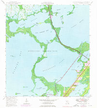
1947 Map of Blackwater Sound
USGS Topo · Published 1976About this map
Key Largo stands at the heart of this coastal study, showing the upper Florida Keys during a period of transition as development pushed south. The Overseas Highway threads through the island chain, crossing Cross Key and spanning Jewfish Creek to connect the mainland with these subtropical outposts. Much of the western waters and islets, including Shell Key and Boggy Key, are preserved within the boundaries of Everglades National Park, showcasing the intricate system of mangrove keys and sounds that define the region.
Find a feature on this map
36 named features on this map. Tap any name to fly to it.
Don’t see what you’re looking for? This feature index may not catch every label — zoom into the map to look around manually.
Map Details
Editions of this 1947 Blackwater Sound Map
3 editions found
Other maps of this area

1947 · Garden Cove
USGS Topo · 1:24,000

1947 · Rock Harbor
USGS Topo · 1:24,000

1947 · Blackwater Sound
USGS Topo · 1:24,000

1949 · Blackwater Sound
USGS Topo · 1:24,000

1949 · Rock Harbor
USGS Topo · 1:24,000

1949 · Garden Cove
USGS Topo · 1:24,000

1949 · Card Sound
USGS Topo · 1:24,000

1950 · Glades
USGS Topo · 1:24,000

1956 · Card Sound
USGS Topo · 1:24,000

1956 · Glades
USGS Topo · 1:24,000