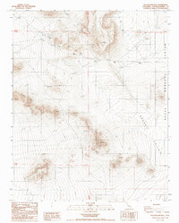
1988 Map of Blackwater Well
USGS Topo · Published 1988About this map
Black Hills dominate this arid landscape within the eastern reaches of San Bernardino County, where the desert floor is marked by the eponymous Blackwater Well. This 1988 provisional survey captures the area at a time when much of the eastern terrain fell within the boundaries of the Naval Weapons Center, highlighting the intersection of military land use and the High Desert. The map serves as a record of early water management and mining attempts, featuring a desert Guzzler for wildlife or livestock and a lonely Prospect in the central hills. Wide expanses like Grass Valley are traced only by a network of 4wd tracks, suggesting the isolated and undeveloped nature of the region during the late twentieth century. These primitive routes provide the primary access through the townships, connecting scattered benchmarks and natural landmarks across the basin and range topography.
Find a feature on this map
14 named features on this map. Tap any name to fly to it.
Don’t see what you’re looking for? This feature index may not catch every label — zoom into the map to look around manually.
Map Details
Editions of this 1988 Blackwater Well Map
This is the sole edition of this map. No revisions or reprints were ever made.
Other maps of this area

1915 · Searles Lake
USGS Topo · 1:250,000

1947 · Trona
USGS Topo · 1:250,000

1948 · Trona
USGS Topo · 1:250,000

1953 · Trona
USGS Topo · 1:250,000

1954 · Pilot Knob
USGS Topo · 1:62,500

1954 · Cuddeback Lake
USGS Topo · 1:62,500

1955 · Opal Mountain
USGS Topo · 1:62,500

1956 · Fremont Peak
USGS Topo · 1:62,500

1957 · Trona
USGS Topo · 1:250,000

1960 · Trona
USGS Topo · 1:250,000