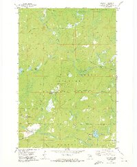
1972 Map of Blackwell
USGS Topo · Published 1974About this map
The Peshtigo River winds through this heavily forested portion of the Nicolet National Forest in the early 1970s. The settlement of Blackwell serves as the primary hub, situated near the Blackwell Job Corps Center and a Trailer Park. This era of the landscape is defined by a transition from early-century infrastructure to modern recreation, visible where an Old Railroad Grade follows the Rat River valley near modern sites like the Bear Lake Campground. Numerous small water bodies, including Shabodock Lake, Purdy Lake, and the artificial CCC Pond, are scattered across the terrain, connected by a network of drainage creeks like Piledriver Creek and Stoney Creek. Local resource extraction is noted by a Gravel Pit near the town center, while remote areas are accessed via Burnt Bridge Road and Trestle Road.
Find a feature on this map
41 named features on this map. Tap any name to fly to it.
Don’t see what you’re looking for? This feature index may not catch every label — zoom into the map to look around manually.
Map Details
Editions of this 1972 Blackwell Map
This is the sole edition of this map. No revisions or reprints were ever made.
Other maps of this area

1939 · Goodman
USGS Topo · 1:48,000

1939 · Laona
USGS Topo · 1:48,000

1940 · Thunder Mtn.
USGS Topo · 1:48,000

1942 · Wabeno
USGS Topo · 1:48,000

1946 · Laona
USGS Topo · 1:48,000

1946 · Goodman
USGS Topo · 1:48,000

1950 · Wabeno
USGS Topo · 1:48,000

1951 · Wabeno
USGS Topo · 1:48,000

1951 · Thunder Mountain
USGS Topo · 1:48,000

1954 · Iron Mountain
USGS Topo · 1:250,000