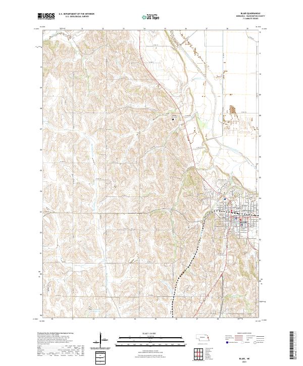
2021 Map of Blair
USGS Topo · Published 2021About this map
The city of Blair serves as the focal point of this Washington County landscape, anchored by the Washington County Courthouse and a grid of streets that includes Herman Blvd and Fontenelle St. The surrounding terrain is defined by a dense network of drainages, most notably Big Papillion Cr and its tributaries, which feed into the Papillion Cr Reservoir W-2. Local agricultural history is visible in the presence of the Cameron Ditch, while the Cuming City Cem north of town preserves the name of a settlement that predated the arrival of the railroad. The map details a complex system of county roads, such as Co Rd 27 and Co Rd P31, which trace the ridges between creek valleys like New York Cr and Lippincott Cr.
Find a feature on this map
65 named features on this map. Tap any name to fly to it.
Don’t see what you’re looking for? This feature index may not catch every label — zoom into the map to look around manually.
Map Details
Editions of this 2021 Blair Map
This is the sole edition of this map. No revisions or reprints were ever made.
Other maps of this area

1893 · Fremont
USGS Topo · 1:125,000

1896 · Fremont
USGS Topo · 1:125,000

1955 · Fremont
USGS Topo · 1:250,000

1957 · Fremont
USGS Topo · 1:250,000

1958 · Fremont
USGS Topo · 1:250,000

1968 · Kennard
USGS Topo · 1:24,000
1968 · Arlington
USGS Topo · 1:24,000
1968 · Fort Calhoun
USGS Topo · 1:24,000
1969 · Orum
USGS Topo · 1:24,000

1970 · Herman
USGS Topo · 1:24,000