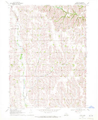
1969 Map of Orum
USGS Topo · Published 1972About this map
The rolling agricultural uplands of Washington County are captured here in the late 1960s, centered on the small settlements of Orum and Spiker. The map reveals a landscape defined by an extensive network of rural education and faith, evidenced by numerous country schoolhouses like March Sch, Bisbee Sch, and Rose Hill Sch. The township boundaries of Herman and Fontanelle divide the terrain, which is drained by the meandering courses of Bell Creek and the headwaters of Little Papillion Creek. Genealogists will find particular value in the localized cemeteries, including Vacoma Cem and the descriptively named Gods Acre Cem, which reflect the early pioneer heritage of these Nebraska plains. The map also documents the proximity of Immanuel Ch and St Pauls Sch, serving as a record of the community hubs that anchored this rural district before the consolidation of the late 20th century.
Find a feature on this map
15 named features on this map. Tap any name to fly to it.
Don’t see what you’re looking for? This feature index may not catch every label — zoom into the map to look around manually.
Map Details
Editions of this 1969 Orum Map
This is the sole edition of this map. No revisions or reprints were ever made.
Other maps of this area

1893 · Fremont
USGS Topo · 1:125,000

1896 · Fremont
USGS Topo · 1:125,000

1955 · Fremont
USGS Topo · 1:250,000

1957 · Fremont
USGS Topo · 1:250,000

1958 · Fremont
USGS Topo · 1:250,000

1966 · Nickerson
USGS Topo · 1:24,000

1966 · Nickerson NW
USGS Topo · 1:24,000

1968 · Fremont East
USGS Topo · 1:24,000

1968 · Kennard
USGS Topo · 1:24,000
1968 · Arlington
USGS Topo · 1:24,000