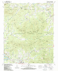
1988 Map of Blairsville
USGS Topo · Published 1988About this map
Blairsville serves as the focal point of this late-century survey, situated at the junction of the Blue Ridge mountains and the headwaters of Nottely Lake. The landscape is defined by the heavy timber of the Nantahala National Forest and Chattahoochee National Forest, which straddle the border between Georgia and North Carolina. The town site includes essential community markers like the local Courthouse, Union General Hospital, and a High School, while the surrounding rural landscape is dotted with family-named gaps and knobs such as Ballard Mountain and Rogers Knob.
Find a feature on this map
128 named features on this map. Tap any name to fly to it.
Don’t see what you’re looking for? This feature index may not catch every label — zoom into the map to look around manually.
Map Details
Editions of this 1988 Blairsville Map
This is the sole edition of this map. No revisions or reprints were ever made.
Other maps of this area

1886 · Dahlonega
USGS Topo · 1:125,000

1888 · Ellijay
USGS Topo · 1:125,000

1892 · Dahlonega
USGS Topo · 1:125,000

1892 · Ellijay
USGS Topo · 1:125,000

1893 · Murphy
USGS Topo · 1:125,000

1896 · Dahlonega
USGS Topo · 1:125,000

1898 · Ellijay
USGS Topo · 1:125,000

1903 · Dahlonega
USGS Topo · 1:125,000

1911 · Ellijay
USGS Topo · 1:125,000

1914 · Murphy
USGS Topo · 1:125,000