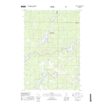
2018 Map of Blaisdell Lake
USGS Topo · Published 2018About this map
The Chequamegon National Forest encompasses this aquatic landscape where the Northwoods transition between the East Fork Chippewa River and the Brunet River. The drainage pattern is defined by a series of interconnected water bodies, from the narrow reach of Black Lake in the north to the wider expanse of Blaisdell Lake and Fishtrap Lake 161. This 2018 survey reveals a modern rural network of forest roads and residential lanes, such as Grandbouche Rd and N Clover Rd, that provide access to private holdings near Hunter Lake and Barber Lake. The presence of several smaller basins like Island Lake, Perch Lake, and Black Dan Lake suggests a high-density glacial lake environment, historically significant for seasonal recreation and timber management. The boundary between Sawyer and Ashland counties cuts across the northern forest tracts near Snag Lake, marking the intersection of these two historic Wisconsin territories.
Find a feature on this map
47 named features on this map. Tap any name to fly to it.
Don’t see what you’re looking for? This feature index may not catch every label — zoom into the map to look around manually.
Map Details
Editions of this 2018 Blaisdell Lake Map
This is the sole edition of this map. No revisions or reprints were ever made.
Other maps of this area

1942 · Clam Lake
USGS Topo · 1:48,000

1943 · Namekagon Lake
USGS Topo · 1:48,000

1944 · Draper
USGS Topo · 1:48,000

1944 · Radisson
USGS Topo · 1:48,000

1945 · Namekagon Lake
USGS Topo · 1:48,000

1945 · Clam Lake
USGS Topo · 1:48,000

1947 · Draper
USGS Topo · 1:48,000

1949 · Radisson
USGS Topo · 1:48,000

1953 · Ashland
USGS Topo · 1:250,000

1953 · Rice Lake
USGS Topo · 1:250,000