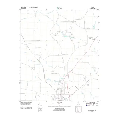
2011 Map of Blakely North
USGS Topo · Published 2011About this map
Blakely serves as the focal point for this 2011 survey of southwest Georgia, showing the city's residential streets and public works like the Blakely Post Office and Mount Hope Cemetery. The landscape is defined by a dense network of tributaries including Kolomoki Creek, Temple Creek, and the Breastworks Branch, which feed into several man-made impoundments. Significant water features such as Lake Kolomoki, Lake Myrtice, and Lake Louise indicate a local reliance on water management and recreation, while the Early County Airport marks the area's modern infrastructure. For genealogists, the map preserves the locations of several burial grounds outside the city limits, including Mercier Cemetery, Hayes Cemetery, and Colomokee Cemetery. The rural layout is anchored by small settlements like Colomokee and Ferrell Crossroads, connected by an extensive system of county roads that navigate the creeks and branches.
Find a feature on this map
64 named features on this map. Tap any name to fly to it.
Don’t see what you’re looking for? This feature index may not catch every label — zoom into the map to look around manually.
Map Details
Editions of this 2011 Blakely North Map
This is the sole edition of this map. No revisions or reprints were ever made.
Other maps of this area

1953 · Dothan
USGS Topo · 1:250,000

1954 · Dothan
USGS Topo · 1:250,000

1955 · Dothan
USGS Topo · 1:250,000

1969 · Fort Gaines
USGS Topo · 1:24,000

1970 · Columbia NE
USGS Topo · 1:24,000

1970 · Columbia
USGS Topo · 1:24,000

1973 · Blakely North
USGS Topo · 1:24,000

1973 · Bancroft
USGS Topo · 1:24,000

1973 · Blakely South
USGS Topo · 1:24,000
1973 · Bluffton
USGS Topo · 1:24,000