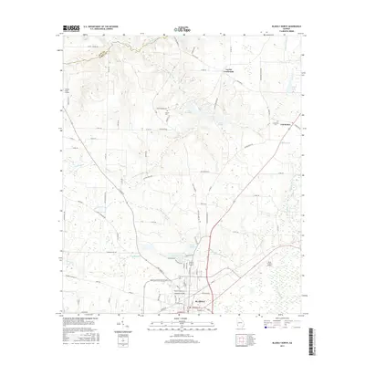
2017 Map of Blakely North
USGS Topo · Published 2017About this map
Blakely serves as the focal point for this 2017 survey of southwest Georgia, showing the city's northward expansion toward the Clay Co Early Co border. The landscape is defined by the headwaters of numerous creeks, including Little Kolomoki Cr and Breastworks Branch, which carve through a mix of agricultural land and wooded lowlands. Local history is anchored by several rural burying grounds such as Mercier Cem and Hayes Cem, while the settlement of Colomokee sits at the intersection of local roads in the eastern section. This modern topographic record captures the transition from the organized street grid of the county seat to the outlying rural networks like Flea Hop Rd and Indian Mounds Rd. Small water bodies like Lake Kolomoki and Lake Yohola are prominent, illustrating the region's managed water resources alongside aviation landmarks like the Early County Airport.
Find a feature on this map
99 named features on this map. Tap any name to fly to it.
Don’t see what you’re looking for? This feature index may not catch every label — zoom into the map to look around manually.
Map Details
Editions of this 2017 Blakely North Map
This is the sole edition of this map. No revisions or reprints were ever made.
Other maps of this area

1953 · Dothan
USGS Topo · 1:250,000

1954 · Dothan
USGS Topo · 1:250,000

1955 · Dothan
USGS Topo · 1:250,000

1969 · Fort Gaines
USGS Topo · 1:24,000

1970 · Columbia NE
USGS Topo · 1:24,000

1970 · Columbia
USGS Topo · 1:24,000

1973 · Blakely North
USGS Topo · 1:24,000

1973 · Bancroft
USGS Topo · 1:24,000

1973 · Blakely South
USGS Topo · 1:24,000
1973 · Bluffton
USGS Topo · 1:24,000