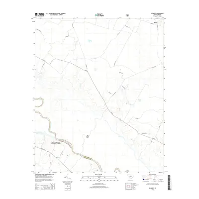
2014 Map of Blakely
USGS Topo · Published 2014About this map
The Santee River corridor defines the southern boundary of this region, where the Williamsburg and Berkeley County line meets the dense woodlands of the Francis Marion National Forest. This 2014 survey documents a landscape of lowland basins and managed timber, punctuated by significant water features such as Wittee Lake and Dog Creek Flats. The settlement of Blakely sits in the northeast corner near the Seaboard Rd rail corridor, while the broader countryside is marked by smaller family and plantation landmarks. Genealogists may find interest in the documented locations of the Betaw Plantation Cem and Sutton Cem, which reflect the area's agricultural history. The transportation network is anchored by Santee Rd and Santee River Rd, connecting isolated farmsteads and ponds like Williams Pond and Billy Cox Upper Pond to the larger river system.
Find a feature on this map
30 named features on this map. Tap any name to fly to it.
Don’t see what you’re looking for? This feature index may not catch every label — zoom into the map to look around manually.
Map Details
Editions of this 2014 Blakely Map
This is the sole edition of this map. No revisions or reprints were ever made.
Other maps of this area

1943 · Trio
USGS Topo · 1:24,000

1943 · Jamestown
USGS Topo · 1:24,000

1943 · Bonneau
USGS Topo · 1:62,500

1946 · Kingstree
USGS Topo · 1:62,500

1946 · Indiantown
USGS Topo · 1:62,500

1949 · Georgetown
USGS Topo · 1:250,000

1967 · Georgetown
USGS Topo · 1:250,000

1974 · Georgetown
USGS Topo · 1:250,000

1986 · Georgetown
USGS Topo · 1:100,000

1986 · Kingstree
USGS Topo · 1:100,000