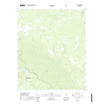
2020 Map of Blakely
USGS Topo · Published 2020About this map
The Santee River corridor defines this landscape, where the border between Williamsburg and Berkeley counties follows the winding waterway. To the south, the protected acreage of the Francis Marion National Forest occupies the lowlands, characterized by drainage systems like Mattassee Br and expansive areas such as Dog Creek Flats. This terrain is a complex network of wetlands including Greater Swamp and Spring Valley Swamp, alongside agricultural features like Ricefield Bay, reflecting the long history of land use in the South Carolina Lowcountry. Cultural markers are concentrated in the uplands, most notably at the Betaw Plantation Cem and the small settlement of Blakely in the northeast. Genealogists can trace family connections through local burial sites such as the Sutton Cem, while water bodies like Wittee Lake and Horse Pond provide geographic anchors in this river-bottom environment.
Find a feature on this map
32 named features on this map. Tap any name to fly to it.
Don’t see what you’re looking for? This feature index may not catch every label — zoom into the map to look around manually.
Map Details
Editions of this 2020 Blakely Map
This is the sole edition of this map. No revisions or reprints were ever made.
Other maps of this area

1943 · Trio
USGS Topo · 1:24,000

1943 · Jamestown
USGS Topo · 1:24,000

1943 · Bonneau
USGS Topo · 1:62,500

1946 · Kingstree
USGS Topo · 1:62,500

1946 · Indiantown
USGS Topo · 1:62,500

1949 · Georgetown
USGS Topo · 1:250,000

1967 · Georgetown
USGS Topo · 1:250,000

1974 · Georgetown
USGS Topo · 1:250,000

1986 · Georgetown
USGS Topo · 1:100,000

1986 · Kingstree
USGS Topo · 1:100,000