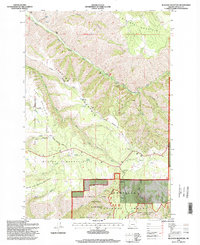
1995 Map of Blalock Mountain
USGS Topo · Published 1997About this map
Blalock Mountain and the steep surrounding ridges define this portion of the Blue Mountains, where the South Fork Walla Walla River carves through deep canyons and basins. The map captures a landscape dedicated to forest management and remote recreation, marked by the southern reach of the North Fork Umatilla Wilderness within the Umatilla National Forest. Historical land use is evident in the inclusion of Demaris Cabin and the presence of specialized camps like Blue Mountain Camp and McDougall Camp.
Find a feature on this map
31 named features on this map. Tap any name to fly to it.
Don’t see what you’re looking for? This feature index may not catch every label — zoom into the map to look around manually.
Map Details
Editions of this 1995 Blalock Mountain Map
This is the sole edition of this map. No revisions or reprints were ever made.
Other maps of this area

1953 · Pendleton
USGS Topo · 1:250,000

1956 · Pendleton
USGS Topo · 1:250,000

1963 · Big Meadows
USGS Topo · 1:24,000

1963 · Andies Prairie
USGS Topo · 1:24,000

1963 · Bingham Springs
USGS Topo · 1:24,000

1963 · Tollgate
USGS Topo · 1:24,000

1963 · Blalock Mountain
USGS Topo · 1:24,000

1963 · Peterson Ridge
USGS Topo · 1:24,000

1964 · Bowlus Hill
USGS Topo · 1:24,000

1964 · Weston Mountain
USGS Topo · 1:24,000