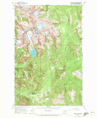
1965 Map of Blanca Lake
USGS Topo · Published 1972About this map
Garland Mineral Springs and the San Juan Campground anchor the lower elevations of this mid-1960s survey, marking established points of human access into the high Cascades. The map transitionally straddles the boundary between Mt Baker National Forest and Snoqualmie National Forest, defined by a series of ice-scoured peaks and drainage basins. The presence of the Columbia Glacier and smaller permanent snowfields beneath Monte Cristo Peak and Kyes Peak illustrates the alpine environment before late-century glacial retreat.
Find a feature on this map
41 named features on this map. Tap any name to fly to it.
Don’t see what you’re looking for? This feature index may not catch every label — zoom into the map to look around manually.
Map Details
Editions of this 1965 Blanca Lake Map
3 editions found
Other maps of this area

1899 · Glacier Peak
USGS Topo · 1:125,000

1901 · Glacier Peak
USGS Topo · 1:125,000

1902 · Skykomish
USGS Topo · 1:125,000

1905 · Skykomish
USGS Topo · 1:125,000

1950 · Glacier Peak
USGS Topo · 1:62,500

1955 · Concrete
USGS Topo · 1:250,000

1957 · Wenatchee
USGS Topo · 1:250,000

1958 · Concrete
USGS Topo · 1:250,000

1962 · Concrete
USGS Topo · 1:250,000

1965 · Captain Point
USGS Topo · 1:24,000