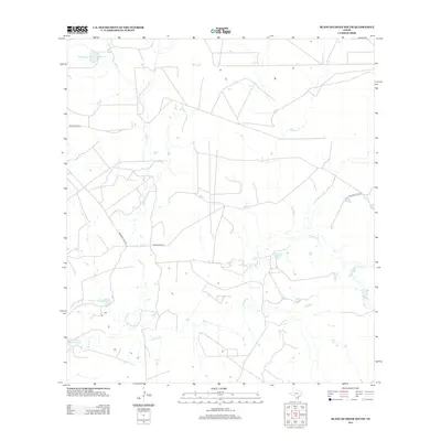
2013 Map of Blancas Creek South
USGS Topo · Published 2013About this map
La Perla Ranch serves as a principal landmark in this arid stretch of South Texas, where the landscape is defined by an intricate network of intermittent watercourses. Primary drainages including Dolores Cr, Blancas Cr, and El Jaral Cr carve through the brush country, feeding several artificial impoundments that are critical to local ranching operations. Among these are Hubbard Lake Number 2, Carlos Vela Lake, and Lake Number 1. This 2013 survey illustrates a sparsely populated region primarily organized around ranching infrastructure and a few arterial routes such as Mangana-Hein Rd. The drainage patterns shown here reflect the seasonal reliance on water management in an environment where creek beds are often dry but remain the primary geographical features for land navigation and property boundaries.
Find a feature on this map
10 named features on this map. Tap any name to fly to it.
Don’t see what you’re looking for? This feature index may not catch every label — zoom into the map to look around manually.
Map Details
Editions of this 2013 Blancas Creek South Map
This is the sole edition of this map. No revisions or reprints were ever made.
Other maps of this area

1933 · Becerra Creek
USGS Topo · 1:62,500

1940 · Aguilares
USGS Topo · 1:62,500

1940 · Mogotes Hill
USGS Topo · 1:62,500

1942 · San Ygnacio
USGS Topo · 1:62,500

1956 · Mogotes Hill
USGS Topo · 1:62,500

1956 · Laredo
USGS Topo · 1:250,000

1979 · Laredo South
USGS Topo · 1:24,000

1979 · O'Keefe Lake
USGS Topo · 1:24,000

1980 · Blancas Creek North
USGS Topo · 1:24,000
1980 · Agua Azul Creek West
USGS Topo · 1:24,000