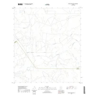
2019 Map of Blancas Creek South
USGS Topo · Published 2019About this map
Blancas Cr and Dolores Cr carve through the dry landscape of the South Texas brush country along the border of Webb and Zapata counties. This 2019 survey documents a region primarily defined by extensive ranching operations and a network of private and county roads. The drainage systems, including the seasonally active El Jaral Cr, dominate the topography, illustrating the natural watercourses that define property boundaries and land use in this arid environment. Significant water management for livestock is evident at La Perla Ranch Lake Number 1 in the southwest. A grid of thoroughfares like Mangana-Hein Rd and several numbered branches of Ranch Road 7918 provide the primary access to these remote ranching tracts.
Find a feature on this map
12 named features on this map. Tap any name to fly to it.
Don’t see what you’re looking for? This feature index may not catch every label — zoom into the map to look around manually.
Map Details
Editions of this 2019 Blancas Creek South Map
This is the sole edition of this map. No revisions or reprints were ever made.
Other maps of this area

1933 · Becerra Creek
USGS Topo · 1:62,500

1940 · Aguilares
USGS Topo · 1:62,500

1940 · Mogotes Hill
USGS Topo · 1:62,500

1942 · San Ygnacio
USGS Topo · 1:62,500

1956 · Mogotes Hill
USGS Topo · 1:62,500

1956 · Laredo
USGS Topo · 1:250,000

1979 · Laredo South
USGS Topo · 1:24,000

1979 · O'Keefe Lake
USGS Topo · 1:24,000

1980 · Blancas Creek North
USGS Topo · 1:24,000
1980 · Agua Azul Creek West
USGS Topo · 1:24,000