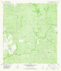
1980 Map of Blancas Creek South
USGS Topo · Published 1980About this map
Dolores Creek and Blancas Creek define the drainage patterns of this South Texas landscape along the Webb Co and Zapata Co line. Photogrammetric methods from 1974 capture an environment largely defined by resource extraction and cattle ranching, marked by numerous Gas Wells and an occasional Drill Hole. The terrain is characterized by brush-covered hills and seasonal watercourses, including San Juanito Creek, El Juanito Creek, and Cerrito Creek. A local topographic high point is identified as George, while a network of private roads provides the only access across these large landholdings. This 1980 edition preserves the placement of an Indefinite Boundary and various fence lines, reflecting the complex land surveying history of this border region.
Find a feature on this map
11 named features on this map. Tap any name to fly to it.
Don’t see what you’re looking for? This feature index may not catch every label — zoom into the map to look around manually.
Map Details
Editions of this 1980 Blancas Creek South Map
This is the sole edition of this map. No revisions or reprints were ever made.
Other maps of this area

1933 · Becerra Creek
USGS Topo · 1:62,500

1940 · Aguilares
USGS Topo · 1:62,500

1940 · Mogotes Hill
USGS Topo · 1:62,500

1942 · San Ygnacio
USGS Topo · 1:62,500

1956 · Mogotes Hill
USGS Topo · 1:62,500

1956 · Laredo
USGS Topo · 1:250,000

1979 · Laredo South
USGS Topo · 1:24,000

1979 · O'Keefe Lake
USGS Topo · 1:24,000

1980 · Blancas Creek North
USGS Topo · 1:24,000
1980 · Agua Azul Creek West
USGS Topo · 1:24,000