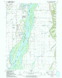
1991 Map of Blanchard Island
USGS Topo · Published 1992About this map
The Mississippi River creates a complex landscape of braided channels and shifting island landforms along the border of Iowa and Illinois. This 1991 survey details the managed wetlands and conservation areas that dominate the river corridor, including the Mark Twain National Wildlife Refuge and the Kilpeck Landing Recreation Area. The map reveals a heavily engineered river valley where an extensive network of drainage features like Frieden Ditch and School Ditch manage the low-lying terrain behind the protective Levee. Small aviation sites such as the Carl Ritter Landing Strip and the Russell Farm Landing Strip dot the agrarian landscape of Drury and Eliza. On the Iowa side, the settlement of Fruitland sits near industrial features like the Pumping Sta and several sand and gravel pits, reflecting the economic utility of the river's alluvial deposits.
Find a feature on this map
62 named features on this map. Tap any name to fly to it.
Don’t see what you’re looking for? This feature index may not catch every label — zoom into the map to look around manually.
Map Details
Editions of this 1991 Blanchard Island Map
This is the sole edition of this map. No revisions or reprints were ever made.
Other maps of this area

1916 · Edgington
USGS Topo · 1:62,500

1935 · Keithsburg
USGS Topo · 1:48,000

1938 · Edgington
USGS Topo · 1:62,500

1941 · Keithsburg
USGS Topo · 1:62,500

1946 · Wapello
USGS Topo · 1:62,500

1948 · Muscatine
USGS Topo · 1:62,500

1949 · Wapello
USGS Topo · 1:62,500

1953 · Toolesboro
USGS Topo · 1:24,000

1953 · Blanchard Island
USGS Topo · 1:24,000
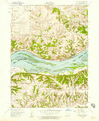
1953 · Illinois City
USGS Topo · 1:24,000