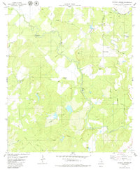
1979 Map of Blanket Springs
USGS Topo · Published 1980About this map
Pecan Bayou and its winding tributaries define this central Texas landscape along the border of Brown and Mills counties. In the late 1970s, this area remained largely rural, characterized by ranching operations and natural landmarks such as Red Peak and Horseshoe Bend. Transportation history is visible through the Old Wire Road and Williams Ranch Road, while the Atchison Topeka and Santa Fe railroad crosses the northern edge of the terrain near Blanket Springs. Local navigation once relied heavily on water crossings, evidenced by Fisk Crossing Ford and Duke Crossing Ford, which allowed movement across the various branches of Pecan Creek and Rough Creek. The presence of several unnamed cemeteries and gravel pits suggests a landscape of small family plots and local resource extraction scattered among the drainage basins of Panther Creek and Blanket Creek.
Find a feature on this map
25 named features on this map. Tap any name to fly to it.
Don’t see what you’re looking for? This feature index may not catch every label — zoom into the map to look around manually.
Map Details
Editions of this 1979 Blanket Springs Map
This is the sole edition of this map. No revisions or reprints were ever made.
Other maps of this area

1885 · San Saba
USGS Topo · 1:125,000

1889 · Brownwood
USGS Topo · 1:125,000

1894 · Brownwood
USGS Topo · 1:125,000

1894 · San Saba
USGS Topo · 1:125,000

1925 · Brownwood 3-b
USGS Topo · 1:48,000

1925 · San Saba 2-a
USGS Topo · 1:48,000

1925 · Brownwood 3-d
USGS Topo · 1:48,000

1925 · San Saba 1-b
USGS Topo · 1:48,000

1925 · San Saba 2-b
USGS Topo · 1:48,000

1925 · Brownwood 4-c
USGS Topo · 1:48,000