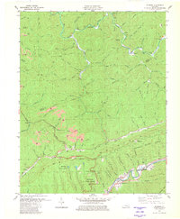
1980 Map of Bledsoe
USGS Topo · Published 1981About this map
The ridge-and-valley landscape of Harlan County is defined here by the sharp ascent of Pine Mountain and the deep drainage basins of the Cumberland River and Greasy Creek. This 1980 survey reveals a region deeply tied to the extraction industry, with numerous strip mines and deeper mines dotting the slopes above Bledsoe and Napier. The southern portion of the map is dominated by the Kentenia State Forest, where terrain features like Hanging Rock and Tunnel Hill rise over the river valley.
Find a feature on this map
104 named features on this map. Tap any name to fly to it.
Don’t see what you’re looking for? This feature index may not catch every label — zoom into the map to look around manually.
Map Details
Editions of this 1980 Bledsoe Map
This is the sole edition of this map. No revisions or reprints were ever made.
Other maps of this area

1887 · Jonesville
USGS Topo · 1:125,000

1891 · Hazard
USGS Topo · 1:125,000

1891 · Jonesville
USGS Topo · 1:125,000

1903 · Harlan
USGS Topo · 1:48,000

1916 · Cornettsville
USGS Topo · 1:62,500

1916 · Harlan
USGS Topo · 1:48,000

1916 · Nolansburg
USGS Topo · 1:48,000

1916 · Hyden
USGS Topo · 1:48,000

1919 · Nolansburg
USGS Topo · 1:62,500

1919 · Hyden
USGS Topo · 1:62,500