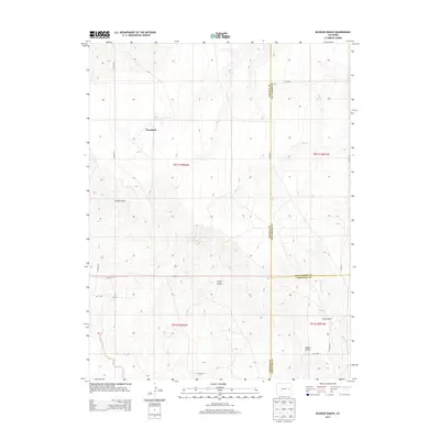
2013 Map of Bledsoe Ranch
USGS Topo · Published 2013About this map
Wareland and Bledsoe Ranch sit at a convergence of administrative boundaries on the high plains, where Lincoln, Kit Carson, and Cheyenne counties meet. This 2013 survey illustrates a landscape dominated by ranching and section-line roads, revealing how geography dictated early Colorado land division. The terrain is defined by dry watercourses like Sand Cr and Wild Horse Cr, which carve shallow drainage patterns into the plateau. Subtle topographic variations appear in named depressions such as Folger Gulch, Aroya Gulch, and Adobe Gulch, features that often served as essential landmarks for navigation and grazing management in an otherwise uniform environment. The grid-like network of rural routes, including Co Road 45 and Co Road 2P, highlights the persistent influence of the Public Land Survey System on the modern western landscape.
Find a feature on this map
23 named features on this map. Tap any name to fly to it.
Don’t see what you’re looking for? This feature index may not catch every label — zoom into the map to look around manually.
Map Details
Editions of this 2013 Bledsoe Ranch Map
This is the sole edition of this map. No revisions or reprints were ever made.
Other maps of this area

1891 · Arroyo
USGS Topo · 1:125,000

1893 · Arroyo
USGS Topo · 1:125,000

1954 · Limon
USGS Topo · 1:250,000

1954 · Lamar
USGS Topo · 1:250,000

1957 · Limon
USGS Topo · 1:250,000

1958 · Limon
USGS Topo · 1:250,000

1958 · Lamar
USGS Topo · 1:250,000

1978 · Sanders Ranch
USGS Topo · 1:24,000
1978 · Boyero
USGS Topo · 1:24,000

1978 · Clifford
USGS Topo · 1:24,000