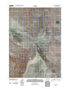
2011 Map of Blitzen NW
USGS Topo · Published 2011About this map
Rock Creek Ranch serves as a central landmark in this high-desert portion of Harney County, illustrating the persistence of ranching operations in a landscape defined by seasonal watercourses. The map traces the winding paths of Rock Creek and Guano Slough, which dictate the placement of human activity in this arid environment. For those researching local history or genealogy, the inclusion of Rock Creek Cemetery provides a specific point of interest, marking a legacy of early settlers in this remote area of southeast Oregon. The road network shown reflects the practical requirements of ranching life, connecting isolated points across the open range as it appeared in the early 21st century.
Find a feature on this map
4 named features on this map. Tap any name to fly to it.
Don’t see what you’re looking for? This feature index may not catch every label — zoom into the map to look around manually.
Map Details
Editions of this 2011 Blitzen NW Map
This is the sole edition of this map. No revisions or reprints were ever made.
Other maps of this area

1955 · Adel
USGS Topo · 1:250,000

1957 · Adel
USGS Topo · 1:250,000

1958 · Adel
USGS Topo · 1:250,000

1962 · Adel
USGS Topo · 1:250,000

1971 · Duhaime Flat East
USGS Topo · 1:24,000

1971 · Blitzen
USGS Topo · 1:24,000

1971 · Butler Hill
USGS Topo · 1:24,000
1971 · Guano Reservoir
USGS Topo · 1:24,000
1971 · Duhaime Flat West
USGS Topo · 1:24,000
1971 · Blitzen SW
USGS Topo · 1:24,000