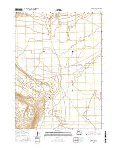
2017 Map of Blitzen NW
USGS Topo · Published 2017About this map
Catlow Valley defines the character of this southeastern Oregon landscape, where the wide desert basin meets the drainage systems of the high desert. This 2017 survey shows a region largely dominated by natural hydrology and large-scale ranching geography, evidenced by the presence of Rock Cr and the winding course of Guano Slough to the south. Human imprints are sparse but significant for genealogy and local history, notably centered on the Rock Creek Cem. The transit of Rock Creek Ln across the valley floor provides the primary access through this arid environment, connecting isolated points of interest across the public land survey sections of t33s r30e and t34s r30e.
Find a feature on this map
7 named features on this map. Tap any name to fly to it.
Don’t see what you’re looking for? This feature index may not catch every label — zoom into the map to look around manually.
Map Details
Editions of this 2017 Blitzen NW Map
This is the sole edition of this map. No revisions or reprints were ever made.
Other maps of this area

1955 · Adel
USGS Topo · 1:250,000

1957 · Adel
USGS Topo · 1:250,000

1958 · Adel
USGS Topo · 1:250,000

1962 · Adel
USGS Topo · 1:250,000

1971 · Duhaime Flat East
USGS Topo · 1:24,000

1971 · Blitzen
USGS Topo · 1:24,000

1971 · Butler Hill
USGS Topo · 1:24,000
1971 · Guano Reservoir
USGS Topo · 1:24,000
1971 · Duhaime Flat West
USGS Topo · 1:24,000
1971 · Blitzen SW
USGS Topo · 1:24,000