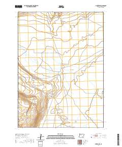
2020 Map of Blitzen NW
USGS Topo · Published 2020About this map
Catlow Valley dominates this high-desert landscape in southeastern Oregon, where the subtle drainage of Rock Creek and Guano Slough defines the hydrologic character of the basin. The map reveals the persistence of early ranching infrastructure and remote homesteading patterns, evidenced by the presence of Rock Creek Cem situated along the lower slopes. This cemetery remains a vital point of interest for genealogists tracing the sparse pioneer history of Harney County. The movement across the valley floor is governed by the primitive route of Rock Creek Ln, which traverses the township lines of this arid region. The spatial arrangement of these water features and the lone cemetery highlights the isolation and environmental constraints that have shaped land use in this part of the Great Basin.
Find a feature on this map
11 named features on this map. Tap any name to fly to it.
Don’t see what you’re looking for? This feature index may not catch every label — zoom into the map to look around manually.
Map Details
Editions of this 2020 Blitzen NW Map
This is the sole edition of this map. No revisions or reprints were ever made.
Other maps of this area

1955 · Adel
USGS Topo · 1:250,000

1957 · Adel
USGS Topo · 1:250,000

1958 · Adel
USGS Topo · 1:250,000

1962 · Adel
USGS Topo · 1:250,000

1971 · Duhaime Flat East
USGS Topo · 1:24,000

1971 · Blitzen
USGS Topo · 1:24,000

1971 · Butler Hill
USGS Topo · 1:24,000
1971 · Guano Reservoir
USGS Topo · 1:24,000
1971 · Duhaime Flat West
USGS Topo · 1:24,000
1971 · Blitzen SW
USGS Topo · 1:24,000