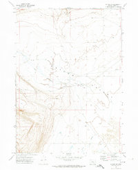
1971 Map of Blitzen NW
USGS Topo · Published 1974About this map
Catlow Valley dominates this high-desert terrain, a geological depression in southeastern Oregon where water and wind shape a sparse landscape. During the early 1970s, the isolated outpost of Rock Creek Ranch served as a primary hub for land management and ranching operations, situated near the seasonal drainage of Rock Creek. A small Cem and a nearby Gravel Pit indicate the long-term human presence and infrastructural needs of this remote ranching community. The map reveals a reliance on aviation and rugged overland travel, evidenced by the Landing Strip and various Jeep Trails that cross the arid basin. In the southern portion, Guano Slough provides a trace of the hydrological patterns that define life in this corner of Harney County, where intermittent water sources and numerous Wells are critical for survival.
Find a feature on this map
12 named features on this map. Tap any name to fly to it.
Don’t see what you’re looking for? This feature index may not catch every label — zoom into the map to look around manually.
Map Details
Editions of this 1971 Blitzen NW Map
This is the sole edition of this map. No revisions or reprints were ever made.
Other maps of this area

1955 · Adel
USGS Topo · 1:250,000

1957 · Adel
USGS Topo · 1:250,000

1958 · Adel
USGS Topo · 1:250,000

1962 · Adel
USGS Topo · 1:250,000

1971 · Duhaime Flat East
USGS Topo · 1:24,000

1971 · Blitzen
USGS Topo · 1:24,000

1971 · Butler Hill
USGS Topo · 1:24,000
1971 · Guano Reservoir
USGS Topo · 1:24,000
1971 · Duhaime Flat West
USGS Topo · 1:24,000
1971 · Blitzen SW
USGS Topo · 1:24,000