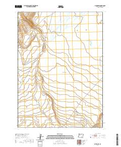
2020 Map of Blitzen SW
USGS Topo · Published 2020About this map
Catlow Valley dominates this high-desert landscape in southeastern Oregon, revealing a quiet expanse of the Great Basin characterized by seasonal hydrology and vast grazing tracts. The drainage of Guano Slough meanders across the western portion of the terrain, illustrating the delicate water patterns that define survival in this arid environment. The map details the Public Land Survey System divisions, including townships t34s r30e and t35s r30e, which historically organized the settlement and management of these expansive rangelands. Beyond the natural landforms, a single marker for W Guan stands as a point of interest for researchers tracking historical land markers or early twentieth-century survey points in this sparsely populated section of Harney County.
Find a feature on this map
8 named features on this map. Tap any name to fly to it.
Don’t see what you’re looking for? This feature index may not catch every label — zoom into the map to look around manually.
Map Details
Editions of this 2020 Blitzen SW Map
This is the sole edition of this map. No revisions or reprints were ever made.
Other maps of this area

1955 · Adel
USGS Topo · 1:250,000

1957 · Adel
USGS Topo · 1:250,000

1958 · Adel
USGS Topo · 1:250,000

1962 · Adel
USGS Topo · 1:250,000

1971 · Fish Fin Rim
USGS Topo · 1:24,000

1971 · Beatys Butte
USGS Topo · 1:24,000

1971 · Blitzen
USGS Topo · 1:24,000

1971 · Butler Hill
USGS Topo · 1:24,000
1971 · Guano Reservoir
USGS Topo · 1:24,000
1971 · Coyote Gap
USGS Topo · 1:24,000