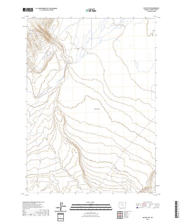
2023 Map of Blitzen SW
USGS Topo · Published 2023About this map
Catlow Valley dominates this high-desert landscape in Harney County, illustrating a vast and sparsely populated basin in southeastern Oregon. This 2023 survey by the U.S. Geological Survey and BLM details the intermittent drainage patterns typical of the Great Basin, where seasonal watercourses like Guano Slough define the terrain's hydrology. The presence of the W Guan route suggests the critical importance of established access roads for ranching and public land management in this isolated region. The map provides a clear look at the Public Land Survey System (PLSS) grid, showing the boundaries of several townships including t35s r30e, which organizes the management of these sprawling rangelands and protected wildlife areas.
Find a feature on this map
8 named features on this map. Tap any name to fly to it.
Don’t see what you’re looking for? This feature index may not catch every label — zoom into the map to look around manually.
Map Details
Editions of this 2023 Blitzen SW Map
This is the sole edition of this map. No revisions or reprints were ever made.
Other maps of this area

1955 · Adel
USGS Topo · 1:250,000

1957 · Adel
USGS Topo · 1:250,000

1958 · Adel
USGS Topo · 1:250,000

1962 · Adel
USGS Topo · 1:250,000

1971 · Fish Fin Rim
USGS Topo · 1:24,000

1971 · Beatys Butte
USGS Topo · 1:24,000

1971 · Blitzen
USGS Topo · 1:24,000

1971 · Butler Hill
USGS Topo · 1:24,000
1971 · Guano Reservoir
USGS Topo · 1:24,000
1971 · Coyote Gap
USGS Topo · 1:24,000