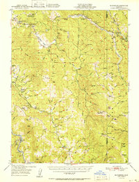
1951 Map of Blocksburg
USGS Topo · Published 1951About this map
Blocksburg serves as a central point in this mid-century survey of the California Coast Ranges, where the rugged headwaters of the Van Duzen River and Mad River divide the landscape. The map captures a transition in land use, showing a network of remote ranching outposts such as Gunlock Ranch, Bliss Ranch, and the Windbigler Ranch alongside growing recreational and conservation footprints. The establishment of Six Rivers National Forest is well-documented here, including the Mad River Ranger Sta and several public camps. Transportation patterns are defined by the narrow corridors of the Larabee Valley and the Northwestern Pacific railroad hugging the riverbanks. Higher elevations are marked by utilitarian and lookout sites like the Lassic Lookout and the unique Snowline Fox Farm, providing a detailed look at the rural economy of Humboldt and Trinity counties before more modern infrastructure reached these ridges.
Find a feature on this map
83 named features on this map. Tap any name to fly to it.
Don’t see what you’re looking for? This feature index may not catch every label — zoom into the map to look around manually.
Map Details
Editions of this 1951 Blocksburg Map
2 editions found

Other maps of this area

1909 · Big Bar
USGS Topo · 1:96,000

1914 · Pilot Creek
USGS Topo · 1:62,500

1915 · Big Bar and Vicinity
USGS Topo · 1:250,000

1918 · Anada
USGS Topo · 1:62,500

1920 · Harris
USGS Topo · 1:62,500

1921 · Dyerville
USGS Topo · 1:62,500

1921 · Briceland
USGS Topo · 1:62,500

1921 · Hoaglin
USGS Topo · 1:62,500

1922 · Island Mountain
USGS Topo · 1:62,500

1922 · Kneeland
USGS Topo · 1:62,500