
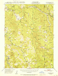
1951 Map of Blocksburg
USGS Topo · Published 1951About this map
Blocksburg serves as a central hub in this mid-century look at the southern Humboldt County mountains, where isolated ranches and forest camps define the social landscape. The rugged topography is divided by the Van Duzen River and the Mad River, with the Northwestern Pacific railroad cutting through the canyon of the Eel River at Eel Rock. This survey records a network of family-held land such as the Bosworth and Windbigler Ranch, alongside specialized operations like the Snowline Fox Farm.
Find a feature on this map
93 named features on this map. Tap any name to fly to it.
Don’t see what you’re looking for? This feature index may not catch every label — zoom into the map to look around manually.
Map Details
Editions of this 1951 Blocksburg Map
2 editions found
Other maps of this area

1909 · Big Bar
USGS Topo · 1:96,000

1914 · Pilot Creek
USGS Topo · 1:62,500

1915 · Big Bar and Vicinity
USGS Topo · 1:250,000

1918 · Anada
USGS Topo · 1:62,500

1920 · Harris
USGS Topo · 1:62,500

1921 · Dyerville
USGS Topo · 1:62,500

1921 · Briceland
USGS Topo · 1:62,500

1921 · Hoaglin
USGS Topo · 1:62,500

1922 · Island Mountain
USGS Topo · 1:62,500

1922 · Kneeland
USGS Topo · 1:62,500